|
The Cochrane Artificial Reef can be
accessed from either the Burnett River or the Elliott River. The trip from the
Burnett takes a little longer, but because the Elliott has shallow water at low
tide and a bar which can be tricky at times, the Burnett is sometimes a better
option. Most of the smaller placements by the Artificial Reef Association are
done from the Elliott River, because of the shorter trip out to the site. Larger
objects such as the Lightships are usually towed into place from Burnett Heads.
 LOCATION
MAP:
LOCATION
MAP:
|
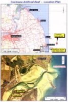 |
This is
the Cochrane
Artificial Reef Locality Map to show where the
Cochrane Artificial Reef is located in relation to the
Bundaberg area and coastline. |
MULTI-BEAM SONAR
SURVEY MAP
|
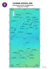 |
The
Multi-Beam Sonar Survey Map is the latest version
of the Cochrane Artificial Reef map. It is the Multi-Beam
Sonar Survey which was
done by the Port of
Brisbane Corporation in January 2009. It shows all objects
deployed on the reef up to September 2008.
The map is in colour, with the datum set in WGS. |
A double-sided laminated copy of the Multi-Beam Sonar Survey Map
with GPS co-ordinates,
is available and
can be purchased for only $4.95 from:-

Tackle World Bundaberg
22 Quay Street
BUNDABERG QLD 4670
Ph: 07 4153 4747
Website: www.tackleworldbundy.com.au
REEF GRID
MAP:
|
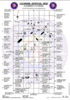 |
This is the Cochrane Artificial Reef Grid Map. This
is the older version and shows the position of all placements as of the 21st September 2006. You will need Adobe Acrobat Reader Version 5 or later to view the file. If you do not have this already, you can download it for free here |
The map shows the position of objects that have been placed,
gives the GPS readings of each object, and shows the depth of
water above each object at minimum low water. The positions
given are on the Australian Geodetic Datum of 1984 (AGD 84) and
position format is in Degrees, Minutes and Decimal Seconds.
Entering the positions in a GPS unit not set to this Datum and
position format will result in a positional error of up to 200
metres.
|
)